Larapinta Trail - Day 14 - Ormiston Gorge to Hilltop Lookout
I sacrificed my rest day at Ormiston Gorge, to return at a later date to shoot it fully with my full kit. I’d also do the Pound Walk whilst there.

A little bit of pre-dawn light painting in Ormiston Gorge.

Dawn light in Ormiston Gorge - forever one of my favourite places to shoot!

Morning sunlight reaches the water of Ormiston Gorge

That light reflecting within the walls of Ormiston Gorge is something else!

Within the walls of Ormiston Gorge
I was now well and truly on a mission to get to the end of the walk! I’d walked over 177km in the previous 13 days and had less than 50km to go. As much as I love being out bush, I love hiking and love being by myself with just nature and photography - 14 days is a long time to be doing nothing but walking! I was starting to look forward to finishing.
Although on the morning of Day 14 I was fresh - well showered, fed with something other than re-hydrated food, and full of joy from talking to new campsite friends… I was still having some discomfort (just mild!). My ankle was swollen and my contact lenses were becoming very gritty and uncomfortable. As much as my tent set up is comfortable, an inflatable mattress is no match for a real bed with a conveniently located-non-spider-or-snake infested toilet with running water available to drink! There is something very liberating about having everything you need to survive with you on your back, but there is also something very comforting in knowing you can drink and go to the toilet conveniently!
I’d been very lucky with contact lenses - usually in the Top End dry season they feel gritty and dry after a couple of days. I was expecting the dry, sandy, dusty air of the Red Centre to be no different! I’d got plenty of spares and also saline solution with me, but hadn’t used either. I did use a rehydrating eye spray though, which was great. And much easier than drops, which I’m incapable of putting in without a mirror (strangely enough, something I don’t carry on a hike!). Anyway, long story short… on the morning I left Ormiston Gorge, I was feeling particularly gritty-eyed, and around 500m after leaving, I rubbed my eye due to the irritation and my contact lens fell out! This has NEVER happened! Luckily I managed to get it stuck to my finger, so could keep it in my hand whilst I removed my pack, found some saline solution and reinserted it. That was a temporary fix whilst I found a replacement contact lens in my pack. Most people wouldn’t know, but I am VERY short sighted. I cannot see further than three inches in front of my face with no contact lenses - so walking with only one would have been very difficult!
Not an ideal way to start the day, but after an unscheduled 20 minute stop to fix my eyes up, I was finally on my way! I remember thinking Mount Sonder looked particularly beautiful that morning - the sunrise light was illuminating her beautifully and I was excited about our hill top campsite that night - the closest and best views of Sonder for the entire hike!
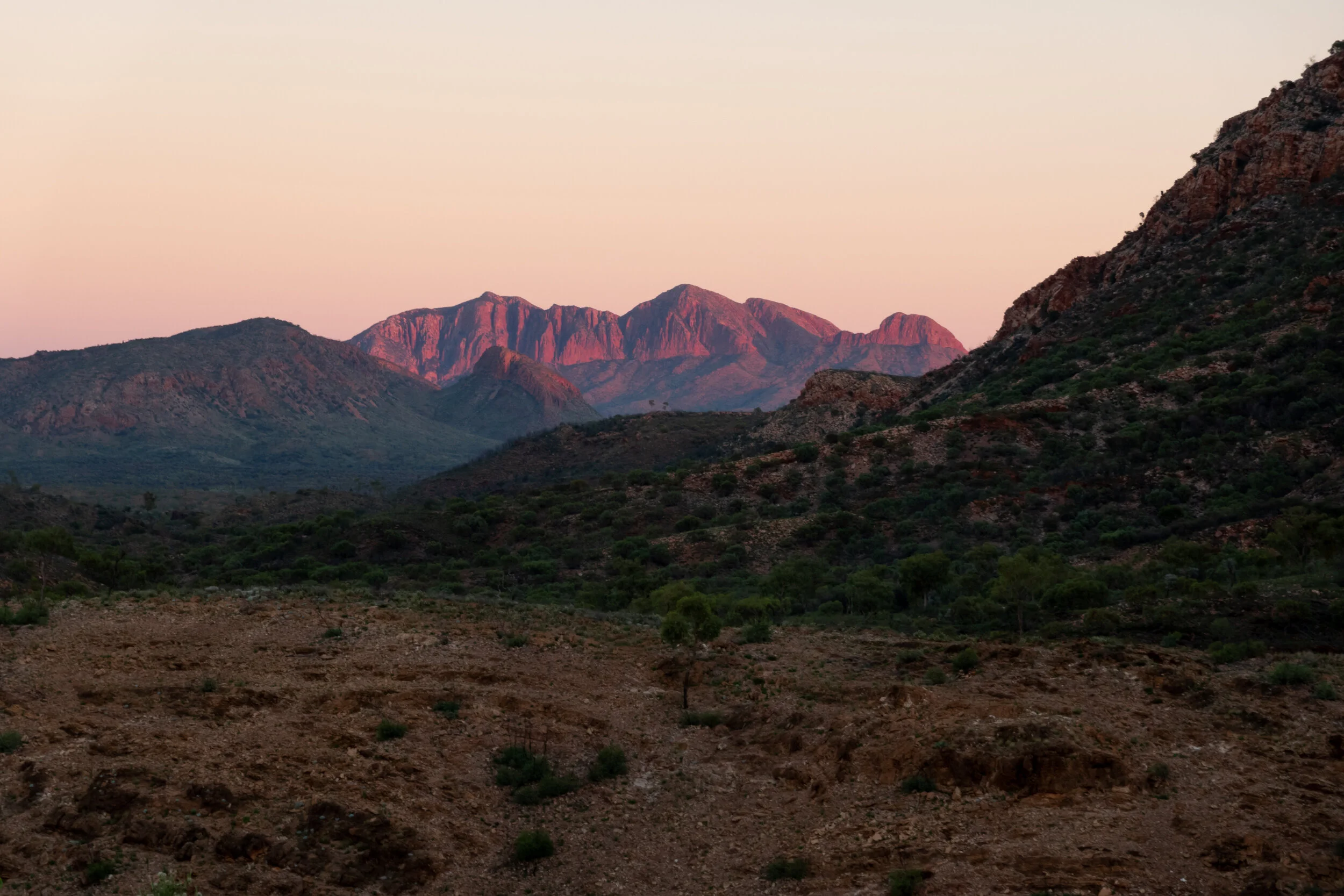
Beautiful Mount Sonder on leaving Ormiston

Leaving Ormiston Gorge

The girls I’d met at Mount Giles Lookout, the couple from Darwin and I, were all camped at Ormiston Gorge that night. I left a few minutes after everyone else. I’d catch them all later - the girls were also planning to camp at the high point I was doing.
The day’s itinerary was to walk the whole of Section 10 - a short section from Ormiston to Finke River Camp (8.9km), top up with water supplies for the night ready for a night at the top of the Hilltop Lookout - another 10km on, past Glen Helen Junction and up to the last high point campsite of my hike.
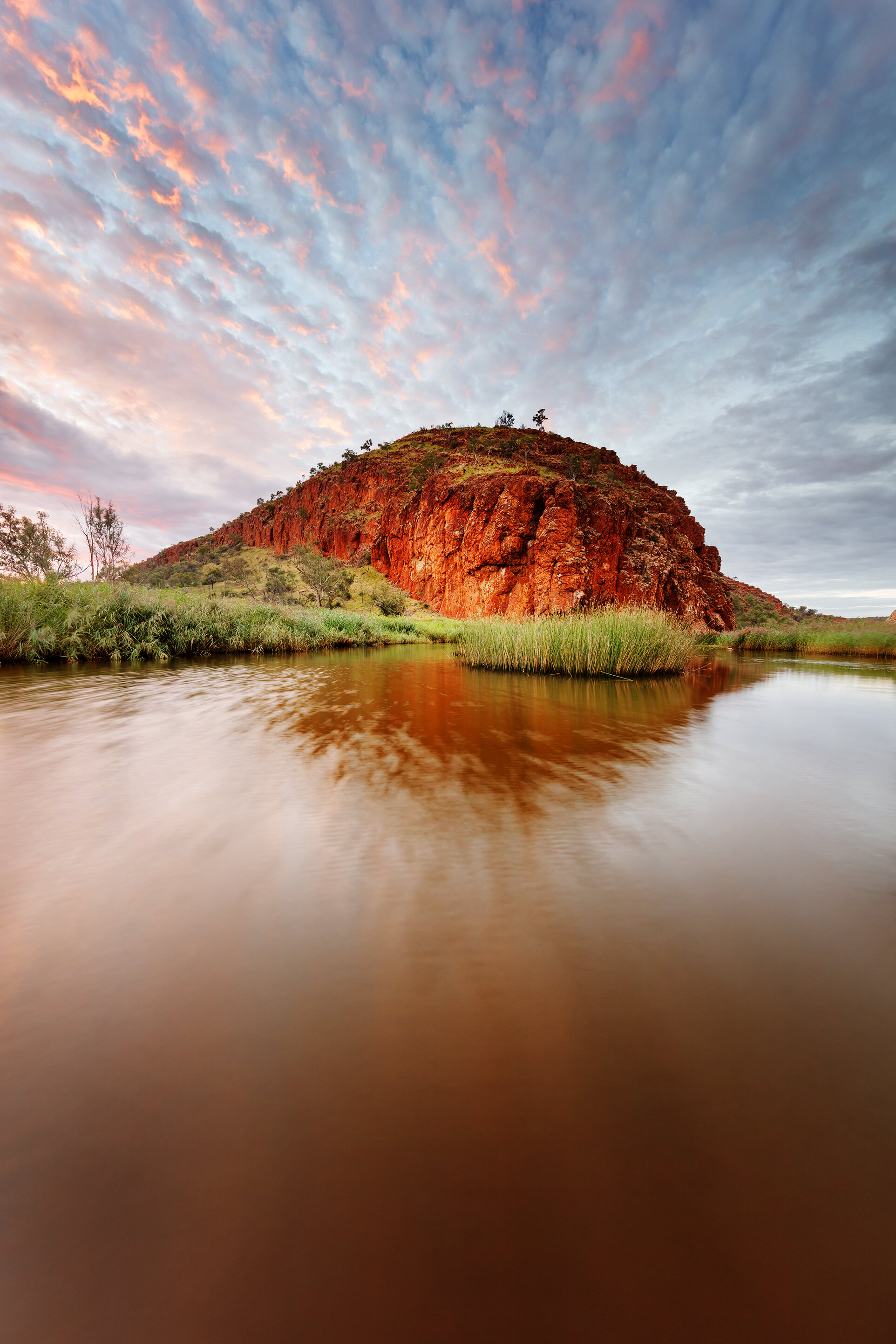
For those with the time, Glen Helen Gorge is an hour detour from the trail - 4km each way. It’s a walk I’d like to go back and do one time! On this trip, I was planning to visit Glen Helen on my week after finishing the hike.

Looking from the Larapinta Trail toward Glen Helen Gorge

Glen Helen Gorge

Glen Helen Gorge, a sunrise image from a visit after my hike
The Larapinta Trail maps were allowing 4 hours to walk the 9km from Ormiston to Finke River camp. The terrain looked flat, and I was hoping I’d be able to walk the section much quicker than that. I was aiming for 2 - 2.5 hours.
I was very nervous about the section around Finke River - due to the rain, I was worried about needing to swim! The couple from Darwin had a couple of friends who’d walked the same area a couple of weeks prior, and they’d said there was a swimming section around there somewhere. The 5 of us walking the same way had all said we’d help each other out though - there wasn’t much distance between us walking so we were bound to catch up to each other at any possible water crossings.
I did have dry bags, but none big enough for my entire pack, only some of the contents! I would much prefer not to get my pack wet if I could help it. I wasn’t strong enough to hoist my entire pack above my head, so my plan was to do multiple trips across with the contents of my pack in separate dry bags!
I arrived in to the Finke River Trail shelter at a perfect time for morning snack! I made great time, probably arriving around 9:45am. When I arrived at the shelter, Ruby was already there talking to another 3 hikers who were heading in the opposite direction to us. A father and son team, and another solo lady - who, when we chatted turned out was another member of the Darwin bushwalking club! We knew of each other through bushwalking circles, so we had a good old chat and a hug to celebrate our solo-female-hikerness on the Larapinta!

Finke River
They all gave us some tips and information on the upcoming water crossings we had. They told us of a few areas to navigate and how to get around it. However, there was also one area we had to swim/wade through. The lady from the bushwalking club was around 10-12 inches shorter than I, and she’d indicated the water was chest height. So, not a 100% swim, but definitely a pack removal and deep wade through the crossing. The area in question wasn’t actually the Finke River, but Davenport Creek, around 2km past the Finke River Trailhead.
Whilst chatting to the hikers coming from the West, the other guys caught up. We chatted for a while and all refilled our water bladders for the rest of the day (and overnight for me and the girls). We all left the Finke River shelter at around the same time, negotiating the large pools of water of the Finke River. It wasn’t long before we came past a deeper section that appeared too difficult to walk around. I tried to scope out a shallower area - I battled downstream through the tall grass hoping to find a dry route to cross, but the water was only getting deeper. Meanwhile, Vaughn and Jane had already de-booted and waded through the crossing. It was only shin deep, but just a hassle to remove boots and I didn’t have any other shoes to wear (I must buy some lightweight Tevas as Havianas thongs really don’t cut it for this). I waded barefoot through the mud at the back of the group, and then we all continued on our way.
The section between that small crossing of the Finke and the deep crossing of Davenport Creek seemed to go on forever! I’m not sure if it was the anticipation of getting through the water crossing, or if it was just misjudgment of the map and the distance - it just seemed to take ages to reach the crossing!
Greeted with the water, Ruby was first to arrive and was already in the water when I got there. I out my pack down and went for a reccy run with her, through the water. We scoped out the shallow and deeper areas. We figured out I was the shortest, but the taller people would be able to make it throught carefully, without removing their packs - just by hoisting them up higher and leaning forward a bit in the deeper areas. My pack sits lower and I was short. My camera gear also sits at the bottom of my pack, so getting the bottom of the bag wet was something I really didn’t want to risk!
I did a second walk through the creek, with my trekking pole, water bladders and boots first. My next trip I had a dry bag in a dry bag in a dry bag, of all my camera gear and electronics. My third trip I’d removed enough of the weight that I could carry my near-empty pack above my shoulder.
Not surprisingly I was the last of the 5 through the creek. We all hung out, snacked, chatted and swam for a while before continuing on our way. We did it! And no one drowned any gear, woo!

Davenport Creek, the chest deep water crossing on Section 11 of the Larapinta Trail
The walk from Davenport Creek up to Hilltop Lookout was mostly uneventful. I was making good time, the climb wasn’t particularly steep and around half way up the hill to the lookout, I decided to stop for lunch. The group of 5 of us had been passing each other from the creek, and I’d ended up at the lead of the group. I hadn’t had lunch and it was probably around midday by this point. I was hungry at Davenport Creek so I definitely felt like I deserved lunch! There was’t too far to go until the top, but I’d found a great patch of shade - and not knowing how much shade would be at the top of the hill it seemed like a great lunch stop! The rest of the hikers all passed me, there was only a few minutes between us all.
I ate my tuna and bean satchet and continued on up the hill. I instantly regretted eating so much and then continuing on a fairly challenging section - my food nearly came straight back out with the exertion! It took a good half an hour or so to feel normal again, but I eventually made it up to the top.

My sunset iphone shot!
There was minimal shade but enough for the group of use to sit and relax for a while. Ruby, Vaughn and Jane and I sat in the shade waiting for Rhianna to join us, before the Darwin couple headed off on to their camp at Rocky Bar Gap for the night.
We’d arrived in good time at the top of the lookout, and had 3G phone service - a nice little spot to relax for the afternoon before setting up camp and organising dinner.
I’d tried to scout out a sunset spot but didn’t come up with a composition I was very happy with. As dusk drew closer and closer, the mosquitoes became more and more insane…. I was in the tent by around 6pm, and decided I would make grab some shots right on sunset - I couldn’t stand being out in the cloud of mosquitoes for too long!
It turned out that I couldn’t deal with them at all - I grabbed a sunset iPhone shot (seriously!), but gave up for the night ready to tackle the scene the following morning instead - the light was going to be better then anyway and I was more energetic in the mornings, generally!