Larapinta Trail - Day 13 - Mount Giles Lookout to Ormiston Gorge

Pre dawn glow - my first shot of Day 13, from Mount Giles Lookout

That sunrise light is softer just before the sun peaks above the horizon!

The day ahead :)
I’d had a great night on top of this lookout - there was no wind, I slept well and awoke the next morning excited to shoot and raring to hike!
As per my normal routine, I packed up my camp and prepped for sunrise shots. My four camp buddies left camp as I was shooting - just before sunrise. I was alone again on the top of a mountain, watching the beautiful morning light. I spent much longer shooting up here than I’d expected. The view to Sonder was spectacular - she was really getting close now! The rock formations and trees up here were also a photographic treat - hanging on for life. I probably left the camp area at around 8:30am in the end - a fairly late start for me, and probably close to 90 minutes behind the others.

Here comes the sun! Time to hit the trail

Red sunrise light

My day first began with a flat, beautiful walk along the top ridge line - the views toward Mount Sonder were beautiful! I had a 4.5km walk to reach the bottom of the hill, beginning with around 3km ish across the top. I wasn’t rushing - just soaking up the serenity! I had a total of 13.5km to walk for the day, to get to Ormiston Gorge. The homeward stretch - where I would refill with my last food supplies, have a meal from the kiosk and probably even an ice cream!


I really like the haziness of these few morning shots - I think it just shows the heat and the exposed atmosphere we hikers experience along the trail!
I began the easy descent from the top of the Heavitree Range. The remaining kilometres in to Ormiston Gorge would be over gentle rolling hills. I was making very quick time - my moving time would have been close to 6km p/hr and as my pack was light I wasn’t needing rest breaks. I was only carrying around a litre of water and was down to my last food. I couldn’t wait to get in to Ormiston for a shower and a relaxing afternoon!


The exposed rolling hills at the end of Section 9


The trail winding through Mulla Mulla flowers and burned remains

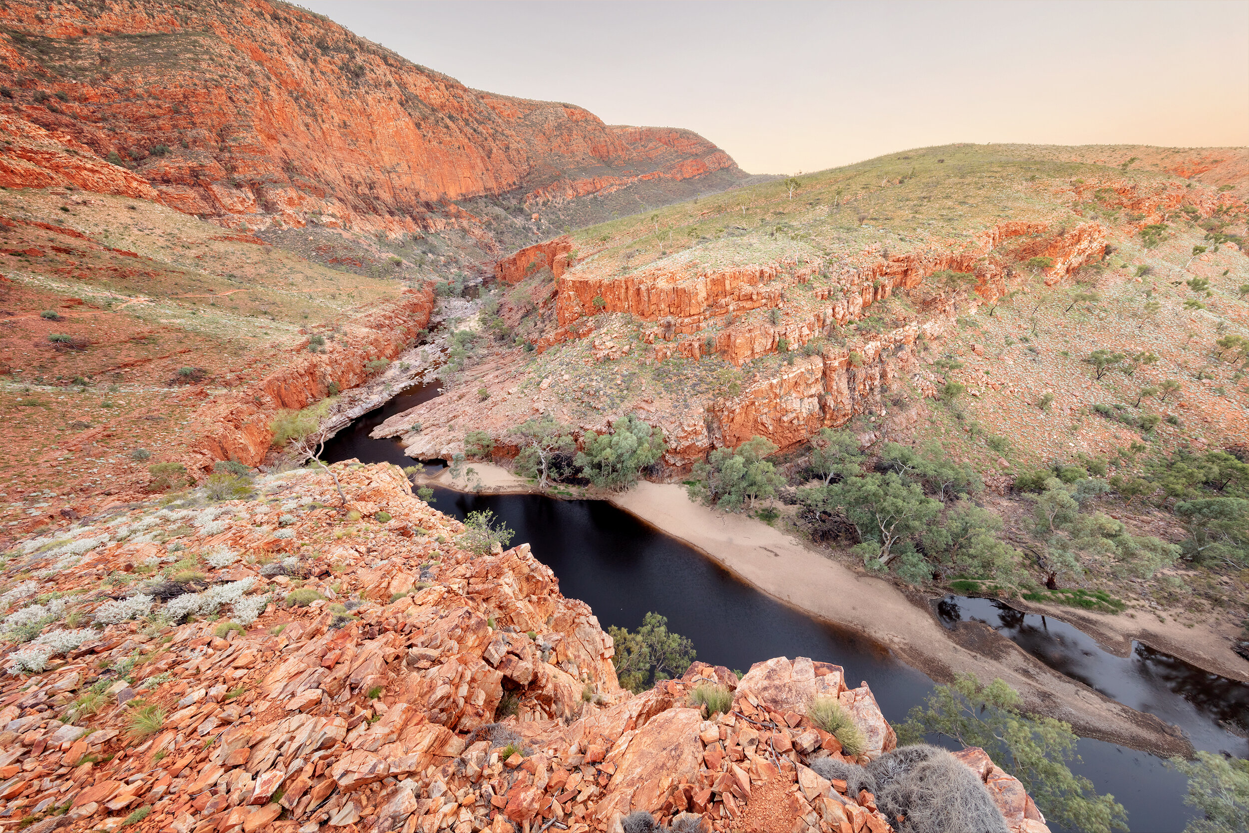
As the Ormiston Gorge rock formation approached, I could see exactly where I was headed having visited the gorge by road many times I recognised the cliffs. I could hear the road. The final stretch of walking for the day crosses the creek and then runs along side it for the last kilometre or so to the gorge. The end of the day always seems the hardest! After the recent rain, the grass was so tall and the creek was full in parts. Crossing wasn’t as simple as what most people would experience in drier times! It was difficult to see the trail through the grass, and so my final creek crossing basically ended in a steep decent down the creek bank into an area where I could avoid taking my boots off! I just had to fight my way through the chest high grass… in a “path of least resistance” direction!
Once in the creek, I followed it for a while but lost the track markers and didn’t really know where it wanted me to go. I could see the road and so decided it’d be easier to just make a beeline for the road and walk alongside it instead. I was marching across the creek toward the road when I found Rhianna moseying around in the creekbed too! She’d basically done the exact same as me - ended up in the creek but couldn’t see any trail markers. So she decided to come along with me for the roadside route instead.
I’d thought it would be easier terrain than the sand and waterhole dodging, but actually the bitumen was SO hard on my feet. You think the Larapinta rocks are hard?! They got nothing on bitumen - those last few hundred metres were very painful for the feet and ankles!
We found the trail markers again, as the Larapinta Trail joined the end of the Ormiston Pound walk. And easy walk through to the carpark, to the trailhead and shelter.
On arriving in to Ormiston Gorge at lunch time, I welcomed a sit down at a real table and chairs, removed my boots and dug in to a foccacia at the Ormiston Gorge kiosk. The food drop store room is located close by, so I spent some time rearranging my pack and restocking my food. I paid camp fees and went to set up camp in the separate Larapinta Trail campers area - away from the main car-camping area. The day use area and campground were very busy, being Easter holidays!

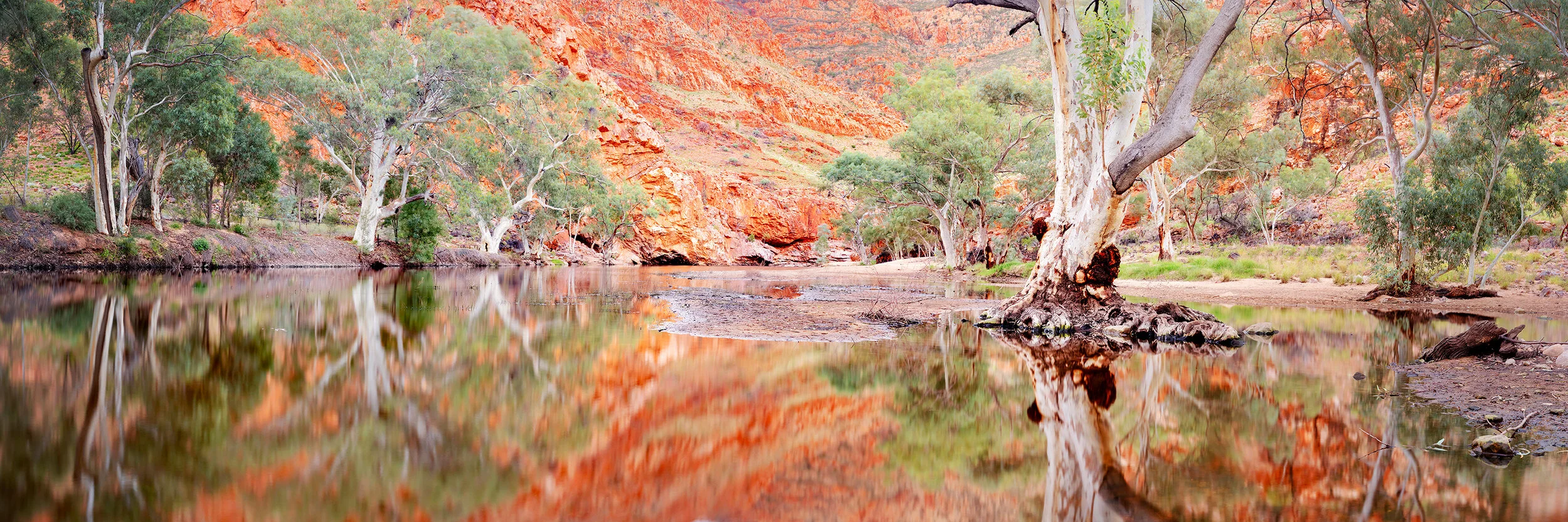
I didn’t actually shoot at Ormiston Gorge whilst I was on my trek. I knew I wanted to spend some time exploring and shooting here post-hike. I wanted to do the day walk, the Ormiston Pound walk. There were lookouts and reflections galore, so I knew I needed more time!
My plans originally were to spend a rest day here to do some of this whilst on my trip. But it made much more sense to push through - I’d had a couple of rest afternoons earlier on and didn’t need the break. It also made more sense for me to return with ALL of my camera gear, rather than just the one lens I was carrying for the hike.
Here’s some of the afternoon and sunset shots I captured from Ormiston after my hike.

Looking in to the gorge from Ghost Gum lookout - sunset