Larapinta Trail - Day 16 - Redbank Gorge to Mount Sonder return

This was it! The last 14km of the trail!
My day began with a 2:45am alarm.
I made a coffee as quietly as I could so as not to wake the others. I wasn’t having breakfast before leaving camp, but I had a couple of museli bars and carried snacks up with me. I’d guess we’d be back at camp by around 9:30am ish ready for the 11am pick up.
My bag was already packed and organised the day before. I did have a sea-to-summit day pack with me, but I decided to use my main pack for better comfort and support - I still needed to carry a bit of weight with the 5kg of camera equipment and a couple of litres of water and snacks.
I was the first to be leaving the campsite - the two girls were also ascending for sunrise but as we all walked at different paces, were departing camp at separate times. Looking back now, it was so nice knowing that they were with me, especially for this final stretch. This was the first time I’d ever hiked at night, and knowing they were behind me and also doing the same thing was a comfort. I’m not sure I’d have had the guts to walk up there in the pitch black if I was 100% alone.
Having done it now though, it was nothing to worry about and since having hiked 3 hours up a mountain in the dark I am now much more comfortable walking in the dark and know that I am capable of it and it’s not a drama, should I need to do so in the future.
The first 500m or so was probably going to be the most challenging - finding the trail! From the Redbank Gorge Larapinta Trail shelter, to get back to the trail I’d have to go through the water crossing if I went back the way I came. I didn’t fancy the hassle of that at 3am! So, I was planning on walking down the creek to join the main Redbank Gorge trail, which had an intersection for day walkers to access the Mount Sonder summit as well. It added a couple of hundred metres on to the distance but time wise, it’d be much quicker and easier.
I’d scouted the intersection on the day prior, so I knew vaguely where I was headed and I had a bright head torch - I learned quickly that those track markers work very well at night!!
Before long, I was on the trail. And immediately, the ascent began.
The track markers also had the kilometres marked on them, and I knew I was heading for 7.1km. These would help me keep my time a little and make sure I didn’t miss sunrise!
I’d been walking for about 25 minutes and hadn’t seen a distance marker. I’d assumed that the first one I’d just missed, but I was hoping I’d missed the second one as well and I was actually heading for kilometre 3 not 2. If I was looking for kilometre 2, I really needed to pick up the pace or I wasn’t going to be at the summit for sunrise! Eventually I could see I was heading toward and arrow with distance marker - after around 30 minutes walking I was at kilometre 3, thankfully! I was on track.
I was back in the zone, concentrating on one foot in front of the other. My torch was illuminating a lot of spider webs and I spotted the coolest looking gecko on the trail in front of me.
The trail went through a couple of dips, but I wasn’t sure if these saddles were ones marked on the map or not - the Larapinta Trail official maps indicated that' I’d pass through a saddle at the 1.6km mark. I’d missed that completely - it didn’t seem to be signed.
I passed the 5km marker, and was very surpsied at the time I was making. The walk wasn’t difficult and I was carrying a light pack but I didn’t expect to be moving so quickly! I had only 2km to go and probably 90 minutes to do it. I stopped for a snack and turned my mobile on - halfway up the mountain I found phone service! Being 4am CST, it meant my family in the UK were awake so I checked in with them!
After a break, I continued on, past the 6km marker and the 7km marker and thought I must be nearly there - any second I’d find the summit cairn.
I didn’t…. but then found an 8km marker. That was odd, as the maps and signage indicated the walking distance was 7.1km. I’d thought earlier it was strange I didn’t see the 4km marker but did see the 5km. So I’d figured out that somehow the marking got messed up and the 4km was skipped. So I’d realised fairly quickly that the 8km marker should actually be the 7km marker and I in theory had 100m or so to go. It seemed like a long 100m, but eventually I found the summit cairn. Realising what had happened with a couple of kilometres to go, I’d picked up the pace a little on 20 or 30 minutes, bringing my arrival time at the summit to 6am on the dot.

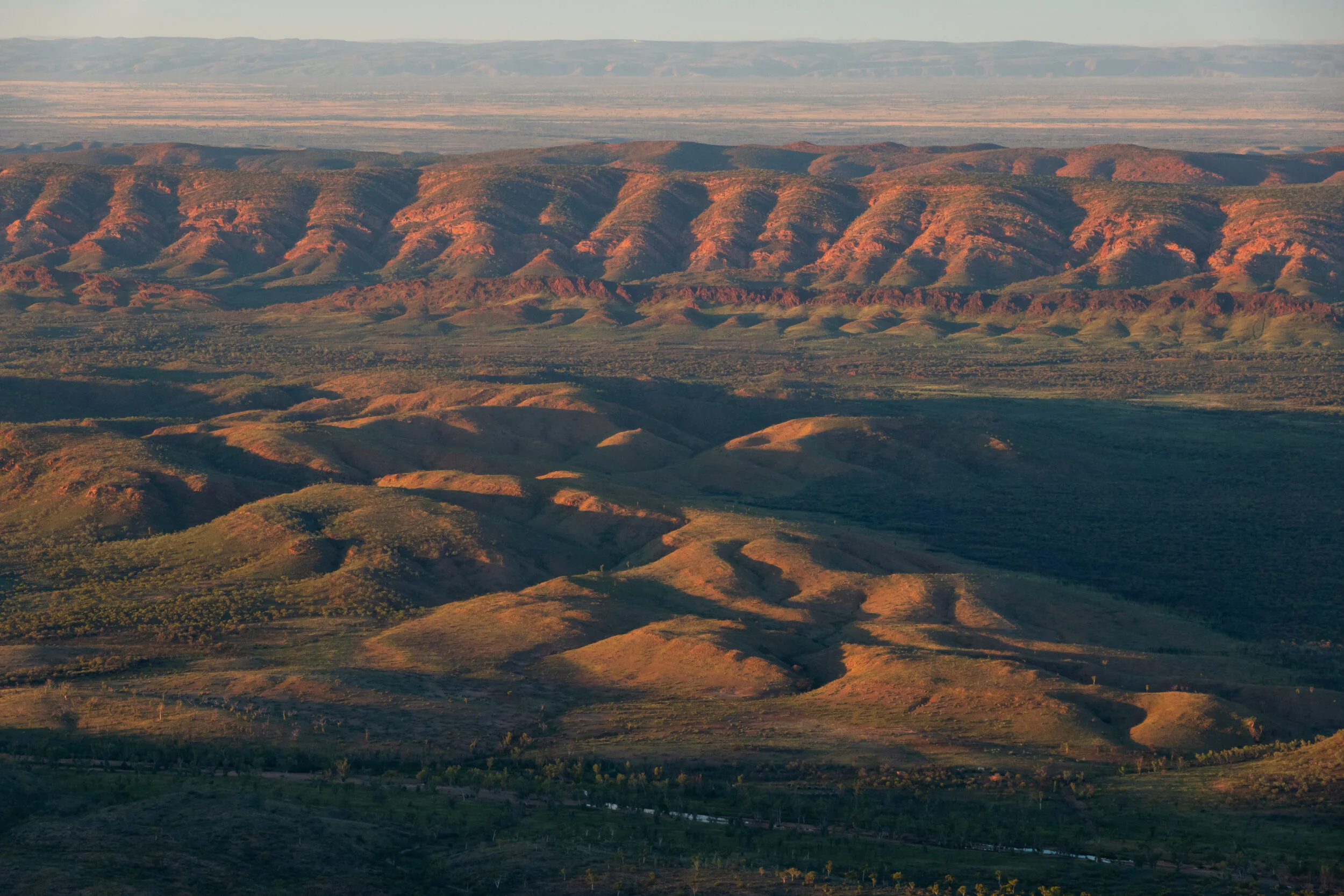
The first light of sunrise was just beginning to appear on the horizon. There was time to have a drink and a snack and fire off a couple of pre dawn astro shots before the sunrise shoot would commence!
This was a point of reflection. Being on the top of the mountain pre sunrise, alone, was a short period of gratitude and awe of the incredible landscape. The whole experience had been absolutely amazing.


First light looking out from the Sonder summit
I had a mini celebration and watched the natural show.
AMAZING. The whole hike.
We’d all loved it.

Me having the time of my life shooting from Sonder :)
For me, the hike up Sonder generally didn’t excite me. I found the view to be a bit of an anti-climax - I’d seen so many sunrises and as spectacular as the view was, I’d had much better. Brinkley Bluff sunrise, Counts’s Point, Mount Giles Lookout and the previous night’s Hilltop Lookout in Section 11 were all killer views.
This summit was moreso for the milestone - it’s the end of the walk.
It was such a great experience to be up there having walked the 7km in the dark. A bit of a personal challenge for me, with that. But I will definitely need to revisit to do a sunset shoot from there too!
All that was left to do was to walk back down to Redbank Gorge, pack up the camp and be picked up by the wonderful guys from Larapinta Trail Trek Support (LTTS). I was hopeful they’d have a seat for me, as I was 2 days earlier than my schedule!


Looking out from Mount Sonder summit