Larapinta Trail - Day 11 - Ellery Creek North to Counts Point
I was feeling great after a successful afternoon’s shooting the previous day, a relax and a great couple of swims… I was up early and managed to pack up most of my camp at around 5am. I started making coffee and breakfast but decided to set up the camera for a little bit of pre-dawn astro photography as I was so early! I drank coffee and snacked whilst I was shooting several long exposures waiting for the sun to come up.
The moon was almost full and bright and dawn light was creeping in - I didn’t create the most spectacular milky way images, but it was nice to get a shot of the stars from the camp that morning. I was on the watch out for dingoes - it was the first night I’d heard them howling through the night, so I knew they were close.


First light in the creek bed at Ellery North
Things were good! My blisters that had begun on day 3 or 4 were no longer an issue. My pack, although broken, was holding up OK and was comfortable. It was also nice and light! Although that would change about halfway through the day as I picked up more food supplies from Serpentine Gorge. I’d developed a painful right heel… not a blister, not a sore, just a swollen heel that was becoming more and more painful. I could work around it after a bit of boot fiddling!
My day was due to be quite a big one. As I’d decided to stay the night at Standley Chasm unexpectedly a few days prior, I was a day behind my schedule. It didn’t matter in terms of my food or supplies but I had a return transfer booked from Redbank Gorge on my 20th hike day and if I’d have stuck to my planned schedule I was going to be a day late. So, I needed to make a day up somewhere. I’d decided that today was going to be the day! I’d planned originally to walk from Ellery to Serpentine Gorge - around 13km and doable easily in half a day.
Serpentine Gorge is accessible by vehicle, so I’d decided to push through here and return to photograph it at a later time. I had a couple of weeks between finishing the hike in Alice and needing to be back in Darwin and was planning to do at least another week or so of shooting after hiking the trail.

Instead, I was going to continue on to Counts Point which was another 6.7km after Serpentine Gorge. I’d have a break at Serpentine Gorge and repack my supplies, have lunch and load up on water as I’d need to carry 5 or 6l up to the high point campsite. It meant my day was going to be about 20km and fairly long, but I was feeling good and ready for it!
The first section from Ellery North to Serpentine Gorge was 12.8km. The maps said to allow 5 hours, but I was finding I was generally much quicker than the maps budgeted for, time wise. I’d estimated I’d do 12.8km in around 3.5 hours, including breaks.
I was out on the trail not long after sunrise, probably around 7:15am. It was a beautiful morning - I really loved walking the direction I did (east to west), as I loved having the early morning light behind me. Typically with landscape photography I want to be capturing what the light is shining on to, so it was the best light to be able to see compositions as I was walking!
The new trail from Ellery North was great! It was mostly flat… it was easy to see the trail despite the high growth around. I really noticed the flowers this morning! I mean, there were flowers everywhere and they were always beautiful but this morning they stood out even more! Maybe because the trail was quite easy, I could focus more attention on them!


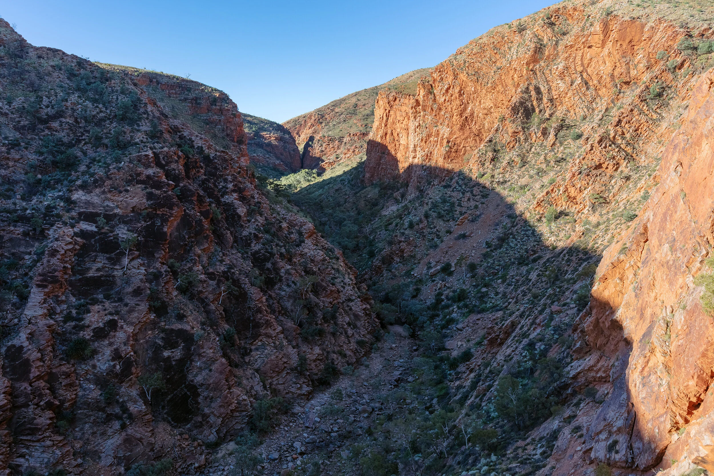
I headed toward the west junction quickly, the trail running along the northern side of the ranges. After around 2km, there was a small rise which provided a great view across to the ridge line ahead - the gap on the right of the below shot is where I was headed to get through to the southern side of the range and rejoin the original trail.


The trail leads through open country… not much shade here!

Typical ghost gum country!
Just before I continued through to the south side of the range (which was via a gorge, not over a saddle, as I’d thought!), I stopped for a morning snack break and a chat to the zebra finches and wagtails. It was only 9:30am and I’d covered just about 9km in two hours, so I was pretty happy with the pace.

Heading through to the southern side of the ranges

Zebra finch chats :)

I was pleasantly surprised by this cross through the ranges - so beautiful and cool!

AND WATER! This section was a bit scrambly and slow, but I’d made good time.
I arrived in to Serpentine Gorge trail camp area at around 11am, and stopped to fill up on water, ready for my ascent that afternoon. I then had to walk another kilometre or so to get to the main carpark for the logbook and junction for the trails continuation along Section 8. The food drop container was located a very short way along the Section 8 portion of the trail - after the public carpark area. Here, I ate lunch and snacks, offloaded flat batteries and picked up all my new supplies and changed my clothes! It felt like I used up a lot of time at Serpentine Gorge, probably leaving there at around 1pm. The hottest part of the day - my favourite for hiking up a big hill (haha!).
I didn’t shoot at Serpentine Gorge at this time but below are a few of the shots I captured from a visit by car, after my hike.

Serpentine Gorge

Serpentine Gorge - panoramic
Lookout above Serpentine Gorge

Looking in to Serpentine Gorge - I love the cycads and blue-ish Pine trees!

The back of Serpentine Gorge
Eventually I continued on my ascent up to camp that evening - at Counts Point. I had 6.7km to reach the Counts Point junction, and I do remember this section feeling very long. The ascent itself was steep and I had a full pack with extra water supplies - I needed a few extra breaks due to my pack weight and the fact I’d already covered a fair amount of kilometres for a day. I didn’t shoot the ascent at all (I really must have been concentrating on the “one-foot-in-front-of-the-other” thing on this afternoon!
Although the map appears to be fairly flat terrain across the top of the ridge line for the last couple of kilometres in to Counts Point, I remember it feeling like a constant steady incline. I was very hot and tired by the time I arrived at the junction (photo below!), to then realise that I still had another 700m to walk up a hill straight in front of me that looked way too steep for me to manage! It took me nearly 30 minutes to walk that last 700m as I was so tired.

I arrived at Counts Point quite late in the day. I was at Counts Point Junction at around 3:15pm, and probably stumbled upon Counts Point at around 4pm ish. I quickly realised it was all worth it. Arriving at Counts Point was great - such an iconic Larapinta Trail view. And a bench! A real seat!
The camping options here are very limited. There was one decent sized campsite behind a mini rock wall (a windbreak), but probably only other one small area for one other tent. I was glad I was hiking early in to the season as I’d have been so disappointed to have not found space to camp up here. If you’re wanting to spend the night here, I’d advise you to get in early to snag the best seat (bed!) in the house. Camping here turned out to be a great choice as these shots are some of my favourite of the entire trail.

My camp at Counts Point

Spinifex and the view across the valley (from the Heavitree range where I am, to the Macdhonnell Ranges)

Rolling hills and last light, below

The road (Namatjira Drive), is down here somwhere….

Shapes to the north

Happy photo time!
Please ignore the Nikon strap hahaha - I “borrowed” a lightweight strap from Alice Springs as I left my Canon strap at home. I use a different strap usually but it’s so heavy I didn’t want to hike with my custom strap. I shoot with a Canon 5DSr - currently with a Nikon strap that I still haven’t changed back after 6 weeks! Ewwwww hahahaha

I love the light on these ripples


Zoom in to Mount Sonder’s beautiful ridge shape - with the Sony RX100


Sunset from Counts Point - you can just see Mount Sonder in the distance, the first glimpse of the iconic mountain that ends the trail.